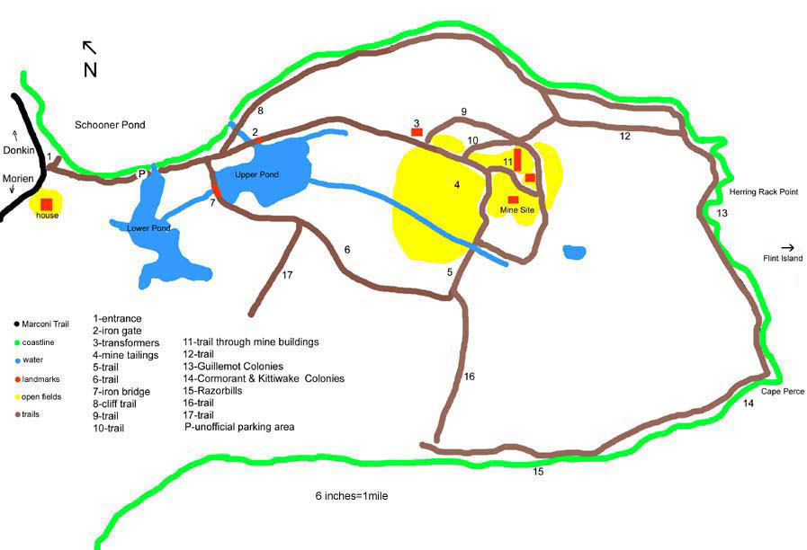
Schooner Pond is our first choice for birding. It has produced more bird species than any other spot we bird here in Cape Breton. It is easy to get around and scenic. I am going to give some detail on the trails and landmarks on the map above. Schooner Pond is a small community located along the Marconi Trail between Donkin and Morien.
Map Details:
1. Turn off the Marconi Trail on to the gravel road leading to the Donkin Mine. Between 1 and 2 on the map is a stretch of beach. Look for shorebirds and sparrows on the beach, seabirds and sea ducks off the beach, and perching birds in the spruce behind the beach. "P" is the spot we park. As long as the road is open and cars are off to the side there should be no problems. From this parking area you can get a view of the lower pond "Schooner Pond". Look for ducks, herons, and egrets in this fresh water pond.
2. Marks the iron gate located over a culvert. Look from here over the upper pond for ducks, herons, grebes and any other bird possible in a cattail marsh. Between 2 and 3 the gravel road skirts the marsh and passes alders, spruce, and stunted hardwood. This is excellent perching bird territory. We have spent hours on this stretch of road.
3. Marks the transformers for the mine and the entry to the mine site.
4. The mine site is a large area of fields surrounded on all sides by alders and willow. Walking around the edge of the fields and watching in the alders has produced interesting sparrows, hawks, and warblers.
5. A trail away from the mine lies across a culvert. Some equipment discarded on the edge of the site marks the way to the trail marked "5". Cross the culvert and pick up the trail along the edge of the tailings. Trail 5 is great for perching birds.
6. This trail is growing in a bit but is still easy to follow. Look for sparrows, warblers and hawks. Stay on trail "6" and you will return to the upper pond. From "7" you get a different view of the upper pond.
7. Marks an iron bridge returning you to the main road and your car. People wanting to walk trails 1, 2, 3, 4, 5, 6, to 7 should allow about an hour. Birders like us might do it in 2-3 hrs.
8. Marks the cliff trail and is great for seabirds and will take you to the seabird colonies in Morien Bay. These cliffs are no more dangerous than any other. Respect the edge and stay back. Places that have collapsed in the last few years have new trails around the slides. This trail is very scenic.
9. Number "3" marks the transformers and is the point of entry for trail "9". Trail "9" will take you up the hill and around the outer most edge of the mine area. 9. takes you threw hardwoods, and spruce to look for more migrating perching birds. Staying on trail 9 you will be taken down the hill behind the buildings, and around to the discarded equipment where you can join onto trail 5 if you wish.
10. Is a second trail up the hill to the back of mine site, it follows a fence that surrounds the compound. Behind the mine shafts it crosses trail 9 and heads through the woods to trail 12.
11. Is the road through the centre of the buildings and is a favourite birding spot.
12. Can be taken one way to quickly come out to the coast or take you through woods to 13. Through the woods is our choice. When you emerge from the woods Flint Island is straight ahead.
13. Look for the first of the nesting seabirds at 13, Black Guillemots will be under you. Listen carefully you can hear the high pitched whistle.
14. Marks the Kittiwake colony. The cliffs from 14 to 15 are completely occupied by Great Cormorant, DC Cormorant, Kittiwake and Guillemot. When you follow the trail from 14 to 15 you will enter the woods and the coast will be hidden. When the coast is visible again you will be at 15.
15. Marks a look out spot to see Razorbills. I recommend turning around at this point and returning the way you came. I would allow 1.5 hrs to walk the coast out and back and 3 hrs if you bird the coast.
16. Only if you know the area could you find trail 16 from 15. It will bring you quickly back to the mine but you will be wet when you get there.
17. Is a dead end trail but is good for birding. Walk out but come back the way you came.
NOTE: Other trails are hidden around the site. The trails I have shown on the map are easy to follow. If the trail you pick is less than 4 ft wide it is not one I have written about.
back to Cape Breton Birding Hot Spots